(Editorial note that this is the part III blog of our trip. Part II is linked here, part I is linked here and a preamble with links to our full itinerary is here.)
[HIKE DATE: JUNE 30, 2017]
After Gullfoss, we are off. It is now destination Skogafoss, to park a van, and Selgalanfoss to catch our bus which will take us to our hut at Basar for the evening. We’d identified this epic hike, fimmvörðuháls, since we’d read that hiking in this area featured some of the most beautiful views, challenging terrain and more waterfalls than one could count. I did a lot of research ahead of time and although most people chose to do this hike in 2 to 3-day segments, it seemed doable in one day. And while many take the Skogafoss to Basar direction, by going the opposite direction, we gave ourselves the ability to use a full day for the hike and not worry about having to catch a bus on the other side. This also had the side benefit of ending the hike with a way less technical dissent. And while that did make for a more challenging climb at the get-go, I’m so thankful to have crossed the cat spine and steep chain-assisted sections with fresh legs.
Skogafoss is about a 2 hour drive from Gullfos and it’s hard not to get distracted by this magnificent waterfall when we arrive. Unfortunately, we have a bus to catch at Seljalanfoss as well as need some dinner. We quickly grab some fish and chips from a food truck (it’s raining so we eat in the van). All 8 of us then combine into one of the vans leaving the other vehicle in the lot. Seljalanfoss is about 20 minutes away and it’s another mesmerizing waterfall. There is another small food truck and we have a bit of time before we are directed to our all-terrain bus. I have no idea this is “a thing” until this moment and I’m about to quickly learn why.

We aboard our bus and the research I’ve done warns it can be a 2-3 hour trip to the Basar hut even though it’s only a 20 mile trip. In reality, it takes us about 1-1/2 hours. It’s super rugged terrain and we are bopping in our seats. We cross water that I’d never imagine a bus could cross and even pick up some campers stranded out while hiking. The bus ride itself is an adventure.

When we are dropped off, the hut is super basic. There is a kitchen area and the bedrooms are full of shared bunks. You have to remove your footwear to be inside and it’s clear that there is a school group of the teenagers sharing the place for the night. We claim some bunks and then head out to explore.

The Basar hut is nestled in a valley of mountain and glacier and it is absolutely stunning. We each grab a glass of wine (grateful for Lori and her sacrificing her box for this occasion) and take a mini hike to see what awaits us in the morning.
This simple evening of wine and wandering and golden sunlight has to go down as a most cherished memory. We talk and laugh and take in the remote gorgeousness that is Southern Iceland. We are all so very luckily to be experiencing this.


Again, it never gets dark. But we know we have our work cut out for us in the morning (some trail time estimates are upwards of 12-14 hours for completion). We all settle into our bunks by 10 pm hoping our ear plugs and eyeshades are enough to ensure a good sleep despite the teenagers who are also sharing our hut.
Our goal is to be on the trail by 8 am. I think we are all up between 6:30/7 and are packing in the calories while also packing up our bags for the hike ahead.
One of the things James and I did for our trip prep was to bring a bunch of backpacking meals even though we were not actually backpacking. We’d read about how expensive Iceland was and knew we’d be on the road a lot. So, the morning of the hike, we break into the first of many instant meals. This one is granola and, honestly, tastes pretty good. We also make sure we are packed to the gills with nutrition and water (Clif and Lara bars, gels, cheese, salami, bread). We know it’s going to be a long day.
Upon leaving camp, it turns out the trail we explored the previous evening was actually the exact opposite of the Fimm hike. But the beauty of this is that it allowed us to survey our adventure from above. And now we are off.
Almost immediately, it is up, up, up. I’ve said this as Machu Piccu as well as Patagonia, the actual effort was way harder than anything I’d imagined. Luckily, for the Fimm hike, I learned a few lessons from those previous experience — like RESEARCH. I went into both South American adventures with little understanding of what the actual trail conditions would be. But I googled Fimmvordulhals so many times, it’s practically burned into my monitor. I knew it was going to be tough and the first 1/3 of the day, the toughest part from a climbing and up-mountain perspective. The first 1/3 of the hike includes the most elevation change and climbing.


Luckily, we are fresh and I’m feeling good. As we climb and begin our journey, the landscape is breathtaking. Each step gets us higher with a better view and it’s an alien and treeless landscape that feels like a fairy tale. Dramatic rock and stone contrasting with lush green as far as the eye can see. It’s overcast which is welcome. And I have to pause every 15-20 minutes to turn around and take in the dramatic and craggy earth below us.
There are a few other groups out on the trail. The teenagers from our lodge actually quickly overtake us with their speed and laughter and I’m happy to let them go ahead while I adjust my layers. Seeing the hikers both behind and ahead lends scale to the massive landscape. So, so gorgeous.
Soon enough we are at the cat spine after an hour or so of climbing. This is the part of the trail that I knew I’d find the most challenging since it’s narrow with a drop on each side. I don’t exactly have a fear of heights, but I do have a fear of my balance. And while it starts out way easier and better than I’d imagined (I even start filming my hiking buddy, Julie, with my phone), I get to “the step” — basically, a break in the trail that requires a large step or hop over a pretty large crack and drop offs on both sides — which freaks me out a little. I back track and have more friends go before me so I can watch their approach as well as guarantee I have hands/support on both sides. When I finally muster the courage to whip my short legs across the boulders, I actually grab two hands in front of me to help pull me forward. Success! I make it. And I also pretty much realize that I have no hope in ever attempting Angels Landing at Zion in Utah. If this Cat’s Spine freaked me, I can’t even…


After that, there is more technical climbing and descending with ropes and chains affixed to the mountain side for support. And as we climb higher, the terrain starts to become more rocky and barren. When we finally get “towards the top” we have amazing views of glacier, volcano and valley. Here we take the time to eat some lunch and fuel back up. While the hard climbing might be done, the bulk of the day is still to come and we know there is snow and waterfalls in our future (although, we don’t quite have a accurate gauge yet for how much of both we will get).
I am feeling good. This has to be on of the best hikes of my life. I have the perfect mix of fuel, rest and enthusiasm. I am proud of how I’m doing and just so jazzed to be here.
Once we get hiking again, we see some snow patches and hikers ahead of us climbing up through patches of the white stuff. At this point, it’s still patches. But I am a little surprised at how steep the snow covered terrain is and find myself basically kicking in snow “steps” as I carefully make my way up the hill. This is a little freaky, but I get in a rhythm and keep going. At the top of this stage the terrain changes once again and lava rock is everywhere. It’s barren and there is way more snow up here than we’d prepared for. We are basically where the lava flow streamed in the 2010 volcanic eruption and it’s unlike any place I’ve even been in my life. It’s cool, but it’s also grueling. There is so much trudging through the snow. So much. And the only signs that we are headed in the right direction are these trail marker sticks that confirm, ugh, yes, keep on going through the snow.


That said, I get into a rhythm. I’m still feeling good. And the only way out is through. Trudge, trudge, trudge. Keep on keeping on. Here we go.
Luckily, I’ve dressed perfectly. I have the right amount of layers that keep me insulated from the the suddenly cooler and moist temperatures. It feels like we are trapped in a cloud. A cloud on the moon.
I don’t remember how many hours it takes, but we finally get to the hut which, according to all my research, is the unofficial halfway point of the hike. That said, we’ve been hiking for hours so it feels unbelievable that we still might have another half to go. And while I’m still feeling pretty good, some hikers in our group need a little reset. Energy is low, people are cold. So, we stop at the hut, rest a little, take off our shoes and get some food (not a lot of choices, but they do have ramen noodles and hot water for sale).
As we wait, the clouds actually start to clear and you can just almost make out the ocean in the far off distance. The remainder of our hike awaits and we can see the destination.
I think it’s also important to note that at this point, we have seen ZERO waterfalls. In all of the trail recaps I read, everyone stressed more waterfalls than you can count. And we’ve seen zero. We are on full waterfall alert. Let’s keep going, kids!
(It’s also important to note that if you get tired or sick on this hike, there aren’t a lot of options to stop. There are like two huts and no roads — so come prepared, well researched and with plenty of food — this is not a beginner adventure.)
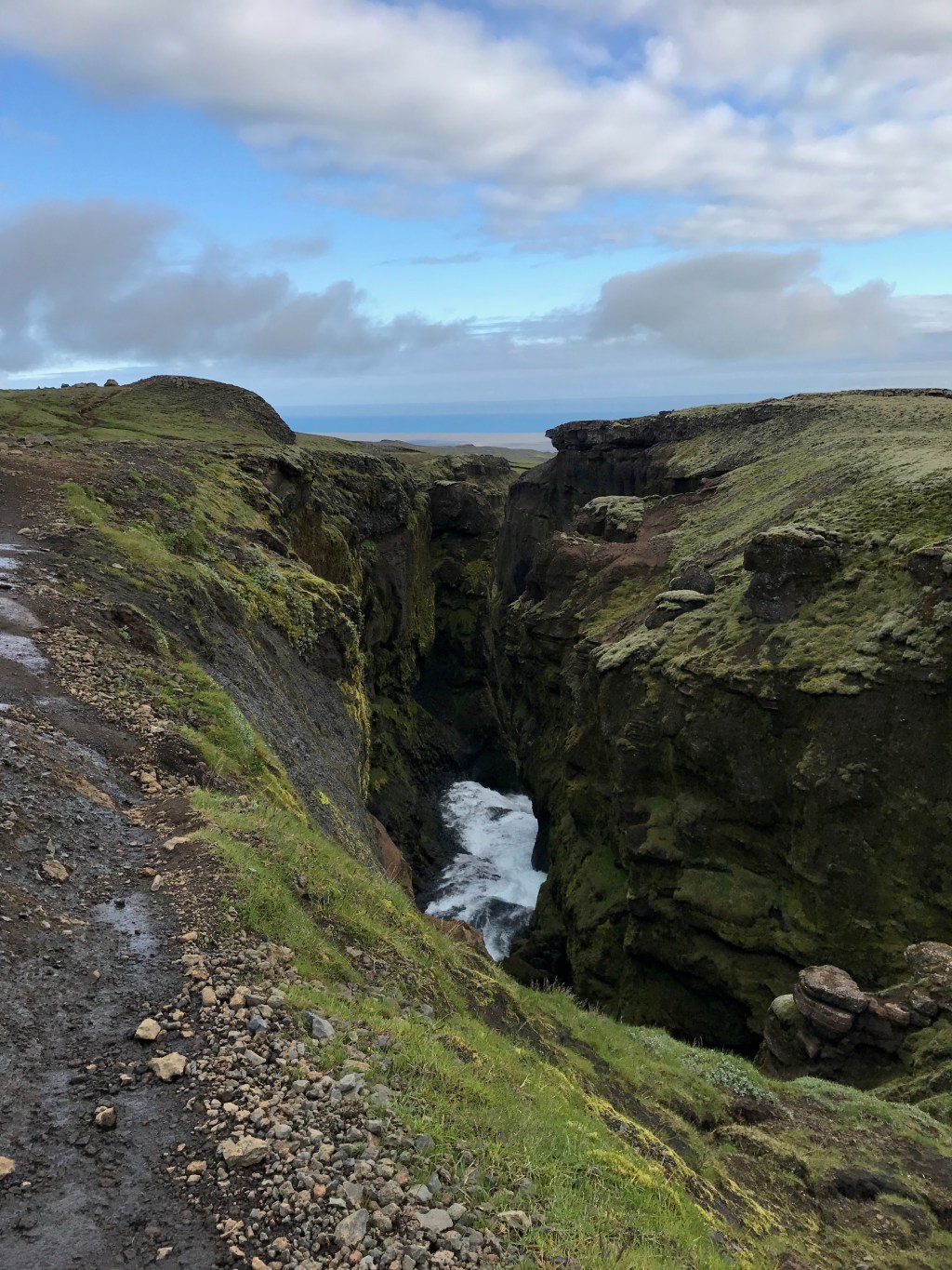
As we come down the pass and follow the river, the change in scenery is more gradual than the initial descent. There are literally miles of rocky boulder-covered terrain with some small bridges over water crossings. But as we continue on, the landscape yields way to canyons and waterfalls that start small but grow in scale with every step. Each waterfall is more magnificent than the one that came before. And while I’m starting to feel the journey in my feet and lower back, I also tell myself that this is a day worth savoring. This is one of those days that we live to experience. And while the pain is temporary, the experience will live on forever.


So many pictures. So many “what the heck?” moments. So many “am I in the Lord of the Rings, right now?” comments. The landscape is absolutely stunning and I’m quickly becoming aware that this might be one of the best days of my life. (In hindsight, yes, I can confirm it was!).
There are sheep. There is blue sky peaking out. There are dramatic canyons and ridges and waterfalls that are beyond my ability to articulate.
At this point, the day has gotten long. We are 10 hours in. All thoughts of dinner and a beer at the Skogar restaurant by 7pm are lost. We aren’t sure how much hiking is left. But I don’t want the lack of a burger at the end to get me down. Look around!! I stuff another Lara bar down my throat. Take in in. Take it all in.


Eventually, the ocean gets closer. Our destination finally feels within reach. And soon enough, we are at the top of Skogar with only the steps down to the parking area as all that remain. I think it’s about 8:30 or 9 when we finally get there and Lori jokingly asks me to run ahead to see of the restaurant at the base of the waterfall is still open (hahaha — no chance — I still want to take it all in!)


Ironically, though, the restaurant IS still open. It’s Iceland. It’s Summer. It doesn’t get dark so closing times are more liberal. And this hiking crew is HUNGRY.
All in all, I think it took us about 12-13 hours for the hike. And while the miles got pretty long towards the end, it was stunning and epic and probably the my favorite hike I’ve ever done to date (in part because I had such a good hiking day).
We congratulate one another over burgers and beers. We yearn for sleep, but we also have to go get the other van which we’d dropped off at Seljalanfoss just the day before. It’s 20 minutes each way, James and I take Dan to retrieve the orange monster.
When we arrive back at camp, it’s been a team effort to get all the tents up and we share a quick drink before climbing in our sleeping bags for a good rest, the sweet surrender of a hard day full of effort and epic views.
Thank you, Fimmvordulhals. Thank you, Iceland.

Leave a comment